1. What is a hurricane?
A hurricane is an intense tropical cyclone with maximum 1-minute sustained surface wind greater than 64 knots [74 mph]) orginating over tropical or subtropical waters. Hurricanes and tropical storms are also associated with organized convection having definite counterclockwise surface wind circulation, often observable in cloud motions and features.
2. Why do hurricanes seem to be restricted to tropical and subtropical ocean areas?
Hurricanes are differentiated from extratropical cyclones by having warm cores (See WEEK 8 Power Point notes: Slides 11-15). Since they are thermal lows that form in the tropics, their initial formation is strongly dependent upon surface temperatures. Ocean temperatures are sufficiently warm to generate such surface thermal lows in the subtropical and tropical ocean areas of the world. Studies of hurricane formation and tracks suggest that an ocean temperature of around 82F (28C) is necessary for the formation, intensificaiton, and sustainance of hurricane strength tropical cyclones.
3. Why do hurricanes not form in equatorial waters even though the ocean temperatures are the warmest there?
Tropical cyclones are formed when divergence related to heating of air columns differentially causes the formation of a thermal low at the surface. Typically, both friction and Coriolis Effect prevent the air coming into the low at the surface from importing as much mass (weight) at the bottom as is going out at the top, and the low intensifies. Since there is no Coriolis Effect at the Equator, too much air rushes into the low at the surface, preventing it from intensifying.
4. Why do hurricane tracks extend from east to west?
Hurricanes and tropical storms form at the latitude of the prevailing easterlies at the surface (called the northeast trade winds) and of the easterlies in the lower 2/3 of the atmosphere above the surface. Thus the "storm track" at the latitude where hurricanes form extends from east to west, rather than west to east, as it does in the middle latitudes.
5. Computations of how strong hurricanes will be on the basis of ocean temperatures ALONE always underestimate their strengths. Why?
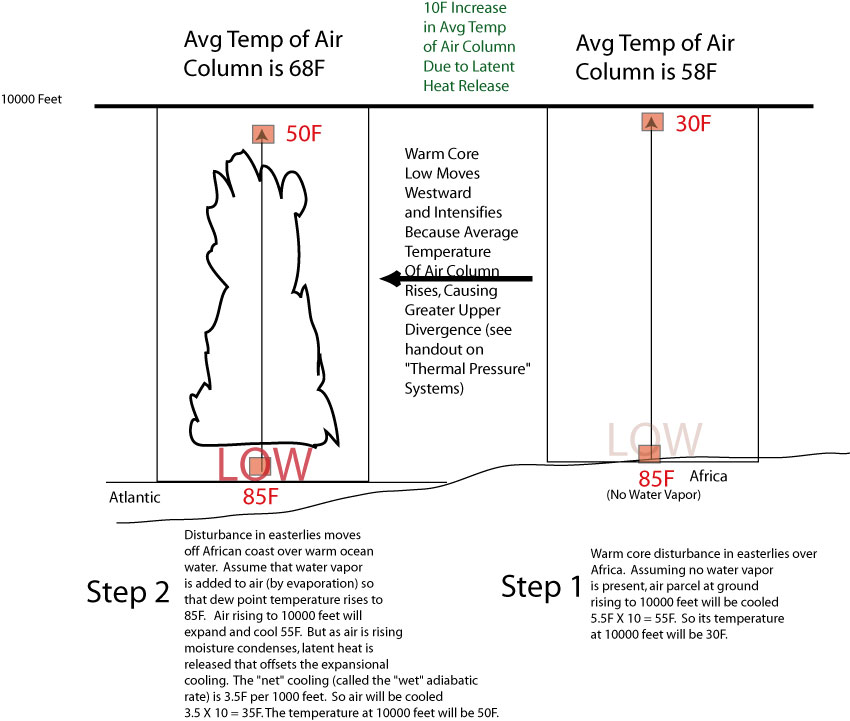
Those computations do not take into account the impact of latent heat release (See Week 8 Power Point notes: Slides 7 & 8), which is actually a more significant source of heating in the air columns at the bottom of which hurricanes form. Since the divergence aloft associated with heating is stronger the greater the heating, the warming associated with latent heat release causes explosive development of the storm.
The water vapor associated with this latent heat release can be traced to the ocean surface. When ocean temperatures are warm, great amounts of water vapor are evaporated into the atmosphere. Thus, though the ocean temperature itself is not enough to explain the occurrence of strong hurricanes, it is related to the water vapor (and latent heat release) that does explain the extraordinary strength of hurricanes.
Finally, in order for a developing hurricane to have a continuous supply of water vapor, the ocean temperatures should be warmer than 82F or so not just for a thin surface layer of ocean, but through a good depth, say 100 meters or so. This ensures that mixing of the ocean waters by the strong winds associated with the hurricane will not bring colder water to the surface and interrupt the supply of water vapor.
6. Why are hurricane wind speeds always the strongest in the forward right quadrant of the storm?
In the forward right quadrant of hurricanes, the storm's forward motion adds to the wind speeds, because they are both in the same direction. Thus if the pressure difference in the forward right quadrant favors a southeast wind at 110 knots, and the storm is moving from southeast to northwest at 25 knots, the actual surface winds will be 135 knots.
Conversely, in the forward left quadrant of the storm, where the pressure difference may be the same, but favoring a northwest wind at 110 knots, the storm motion subtracts from the surface wind speed, which would be 85 knots.
7. Why do hurricanes weaken quickly after passing over the continent?
Hurricanes weaken rapidly when passing over land surfaces for three reasons. First, since the most significant source of heating for the storm is a combination of the ocean temperatures and the high dewpoints (leading to latent heat release) associated with air over the oceans, the upper divergence associated with the storm would weaken as soon as it moves from the ocean.
Second, as a minor weakening effect, when the storm moves on land, surface wind speeds are decreased by friction. And, third, this in turn weakens Coriolis Effect (which is dependent upon wind speeds), causing air to rush into the center of the low, filling it.
8. Despite (7) above, why do hurricanes tend to produce more rainfall when they pass onto the continent?
The inrush of warm, humid air into the center of the hurricane as it weakens and "fills" must be accompanied by rising motion above the storm. Thus, as the storm weakens, more cloudiness and precipitation occurs, even without consideration of any other effect. But, in addition, more rainfall will occur due to topographic lift in hilly areas as well.
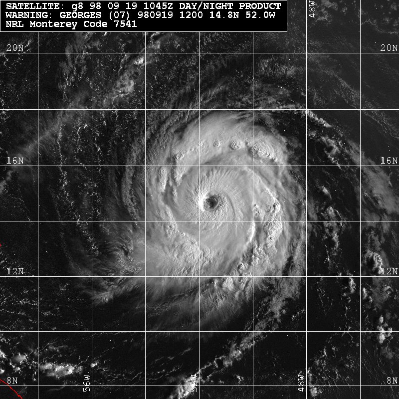
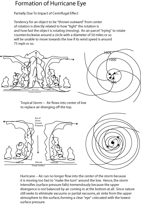
9. Why does the appearance of the clear area called an "eye" form when wind speeds around the eyewall at the surface exceed hurricane strength?
The centrifugal effects on air "attempting" to circulate cyclonically into the small diameter (say, 50 miles or so) cyclone center will not be able to move across the isobars when wind speeds approach 70 mph or so. As a result, divergence aloft will be uncompensated for by air moving laterally into the low at the base of the storm. If this went on indefinitely, a vacuum would form at the surface. The atmosphere compensates for this by sinking from high levels to low levels, resulting in a cloudless, warm, calm storm center known as the "eye".
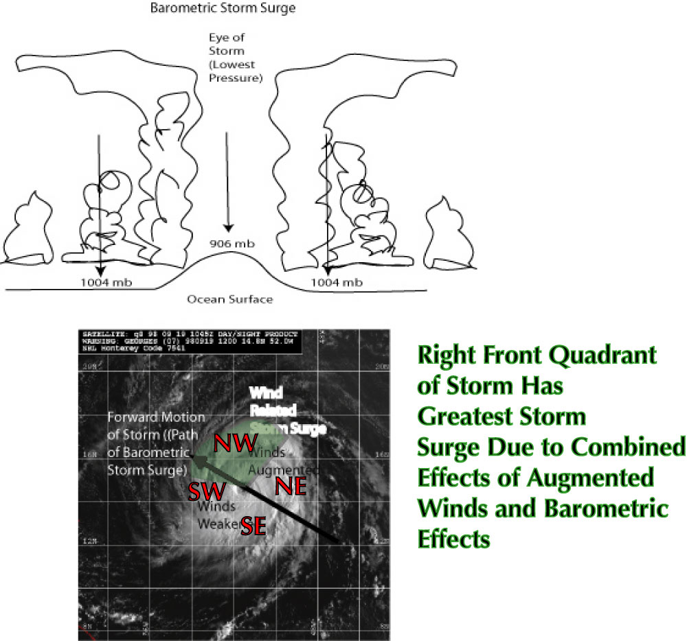
10. What is the storm surge and why is it associated with great loss of life and great damage in coastal sections?
The storm surge is an abnormal rise in sealevel due to two effects. First, a minor effect is the fact that the very low pressure at the center of hurricanes causes an upward bulge in the ocean at the center of the storm. Thus, the ocean levels are higher there than in the surrounding areas, often by a matter of 5 feet or so.
In addition, the major effect has to do with the augmented winds on the right forward margin of the storm physically pushing the ocean against the coastline for a storm moving from southeast to northwest. The combination of these two effects makes, in particular, the forward right quadrant of a hurricane very prone to significant storm surges, sometimes of nearly 25 feet or so.
When such storm surges affect coastal sections for two reasons, additional flooding will take place because swollen creeks and rivers are not allowed to drain into the ocean, and flood the low-lying areas around water courses as well. Second, as the surge approaches the coast, it will build height in the same way that tsunami do as they approach the coastal shallows.
If an astronomical high tide occurs at the same time as all of these things, then the storm surge effects will be maximized and catastrophic flooding will occur. This another reason why the only response to Hurricane Warnings is evacuation.
11. What is the expected impact of global warming on hurricane frequency, strength, and effects.
First, although most warming will occur in the polar and subpolar areas, some warming will occur in the tropics. But it will occur evenly. So that the air columns shown in Fig. 1 will both be warmed. In essence, there will be no differential warming of air columns in the tropics due to Global Warming. This suggests that hurricane numbers, or frequencies, will not be impacted. However, modeling results are mixed, and some show an actual decrease of hurricane numbers and a few showing no change, and fewer showing a slight increase. On balance, one must conclude that current projections do not show a large change in hurricane frequencies.
Second, although the vertical temperature profile of hurricanes is not expected to change during the 21st century, the environmental lapse rate will be shifted towards warmer temperatures.
Third, since globally sea levels are expected to rise, the impacts of storm surges will be worsened both because hurricanes will tend to be more intenst, and the mean height of storm surges will be greater relative to sealevel as we proceed through the 21st century. Thus, storm surges are expected to be of greater depth and extend further inland.
Finally, the increased water vapor expected in the 21st century will also be manifested in higher CAPE values, resulting in more strong and severe thunderstorms, particularly when hurricanes move inland and weaken.